UAV Node Detection: Mid-Air CV
Computer Vision & Autonomous Aerial Navigation
MATLAB
Computer Vision
UAVs
Hough Transform
An algorithmic pipeline to localize ground-based sensor nodes from drone-mounted cameras for autonomous wireless power transfer.
The Engineering Deep Dive
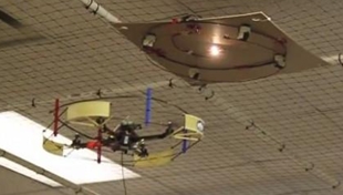
This research addressed the 'Last Meter' problem in autonomous wireless power transfer: how to accurately align a UAV with a ground sensor node when GPS precision fails. I developed a multi-stage detection pipeline that combines geometric and chromatic features to identify nodes from a height of up to 2.0 meters.
The core of the system is a Circular Hough Transform (CHT) paired with a strict RGB color filter. Because the node's appearance changes with altitude, I derived an experimental predictive model to calculate the expected pixel radius ($r$) based on the drone's ultrasonic altitude: r = -38.562h + 80.466. By dynamically adjusting the Hough Transform's search parameters using this equation, I significantly reduced false positives and computational overhead. The system proved robust against up to 50% occlusion and 40-degree tilt, achieving a 90.32% success rate across 16,000 experimental frames.
The Technical Post Mortem
This project taught me the imporance of sensor combination. Relying on the Hough Transform alone often resulted in the algorithm 'detecting' hands or circular clutter as nodes. By layering a color-concentration filter and using the drone's altitude as a constraint for the search radius, I created a 'voting' system. If two of the three methods (Hough, Color, or Altitude-Logic) agreed, the detection was confirmed. This redundant approach is what allowed the system to survive the noisy environment of a vibrating drone in mid-air.
Engineering Constraints
Solving for the 'Impossible' means navigating rigid physical and computational limits:
- GPS error (10ft radius) is insufficient for inductive power transfer.
- Visual occlusion from foliage/clutter up to 50%.
- Variable lighting conditions (5 to 263 Lux).